The dangers that have been overlooked.
The ARkStorm studies look at California as a whole. This section is our founder’s own analysis of specific places they miss. He has identified more than 100, and they will be added here one by one.
Los Angeles and Long Beach harbor
The vast majority of Los Angeles County floodwater ends up in San Pedro Bay, at the foot of the ports of Los Angeles and Long Beach.
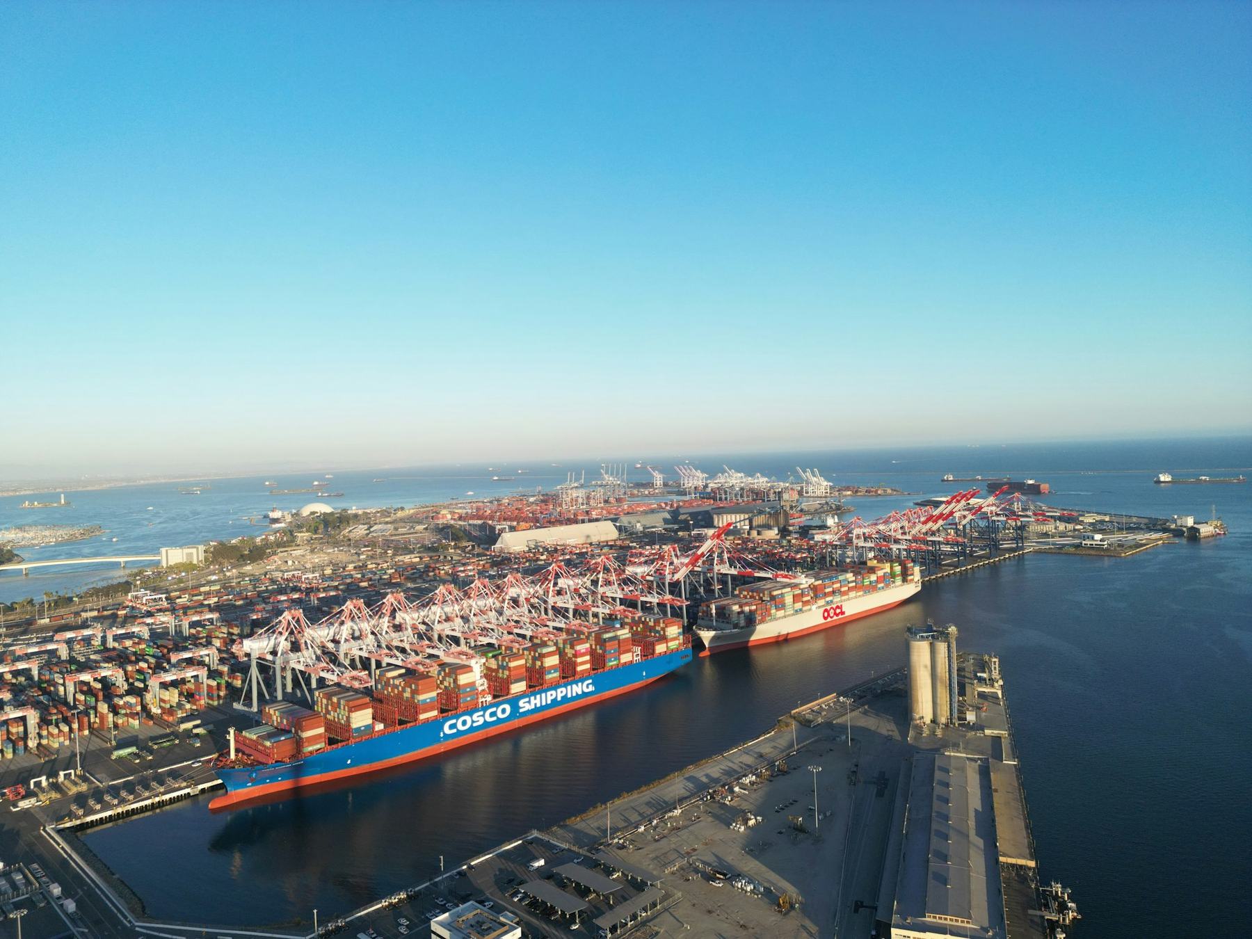
Montrose Chemical Corporation was once the world’s largest maker of DDT. Its waste, along with PCBs, heavy metals and more, was dumped into the bay at the foot of the Los Angeles and Long Beach terminals.
The 2011 USGS scenario shows serious flooding in Los Angeles County and Orange County. The Los Angeles River ends at the Long Beach shipping terminal. The Dominguez Channel ends at the Los Angeles shipping terminal, right next door. The San Gabriel River enters San Pedro Bay just 2 miles to the south.
What a megaflood would do to the harbor.
These are ARkStorm.org’s own rough estimates. They are not findings from any study. The debris figure was worked out with AI tools using FEMA’s flood debris formula. Other guesses run from 20 million to 150 million tons. The cost figure depends on the debris figure, so it is speculation. We are running the numbers again and will update them here.
-
Debris reaching the bay
22 to 50 million tonsToxic flood debris from chemical plants, oil companies, destroyed homes and commercial buildings, thousands of cars leaking oil and gas, raw sewage, thousands of animals, trees, concrete and asphalt.
-
What happens when it hits the water
Winds over 100 mphOnshore winds turn the bay into a washing machine. They churn the runoff together with the DDT, PCBs and heavy metals already on the bottom.
-
Time to clear it
Yearsto clear the toxic debris that flows into the bay.
-
Cost to repair the harbor
More than $1 trillionjust to repair the destruction at the Los Angeles and Long Beach harbor terminals. The 2022 update puts damage across all of California at over $1 trillion.
Tijuana River Valley
We have not found the Tijuana River Valley mentioned in any ARkStorm study.
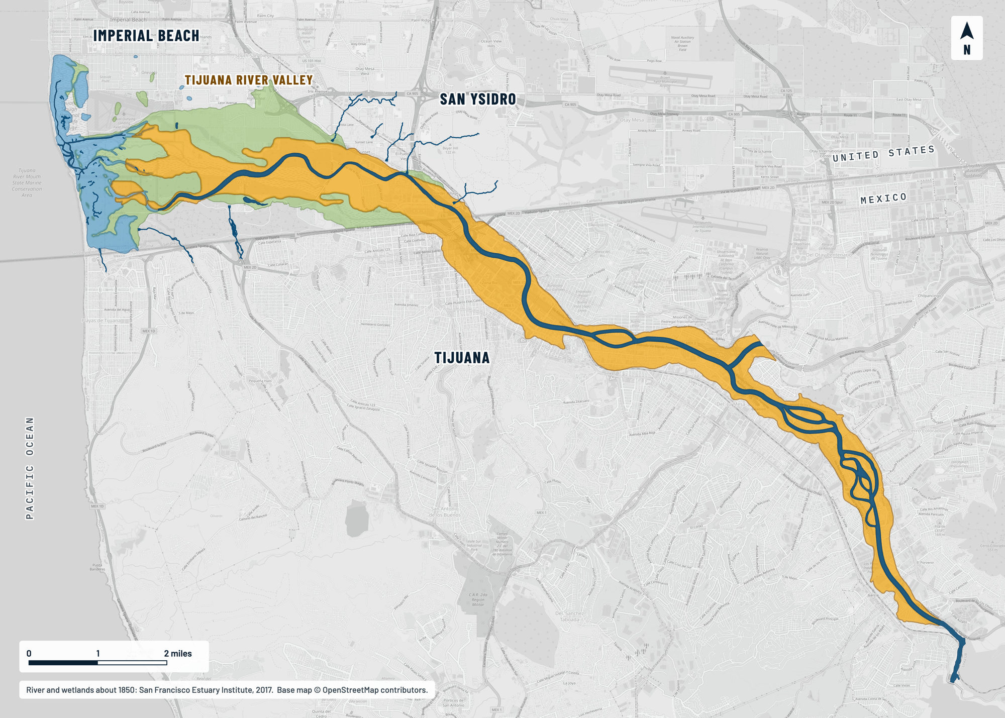
The map below shows the river’s old bed. At one point that corridor is almost a mile wide. When an ARkStorm hits, we expect the Tijuana River to find its old bed again and to push three to five miles past its banks. We expect a complete wipeout there, with substantial loss of life.
We are still gathering research on the Mexican side of the border. More will be added here.
In Tijuana, the river and tributaries such as Alamar Creek run in concrete channels built to move stormwater through the city fast. On the U.S. side the valley is still a natural, soft-bottom floodplain.
The channel is filling up. Oscar Romo, director of the binational group Alter Terra, says sediment has raised the channel floor by about 10 feet. It now takes less water to spill over the levees.
On the Mexican side, thousands of homes built from scrap lumber and tin stand directly in the floodplain. Heavy rain there means fast street flooding and blocked sewers.
The river’s old path, laid over today’s streets
The colors show the Tijuana River as it was about 1850: the wide corridor it moved across, its channel, its marshes and its wet meadows. The gray map underneath is today. This is not the 1862 flood line. It comes from a San Francisco Estuary Institute study of old surveys and maps.
- River corridor
- River channel and streams
- Marsh and tidal flats
- Wet meadow
Homes built in old river beds
FEMA’s flood maps only go back to the late 1960s and early 1970s. They are the basis for flood insurance and building codes.
Developers who covered a small stream and ran drain pipes to reroute it may not have known they were building in an ancient river bed. When an ARkStorm hits, that river will find its old path again.
One subdivision two miles from our founder’s home sits in an old river bed carved by a past ARkStorm. The river will run right through that neighborhood.
Check your addressMore than 100 sites like these.
We’re adding them one at a time. Get an email when a new one is published.
Sources
- Porter, K., and others (2011). Overview of the ARkStorm Scenario. U.S. Geological Survey Open-File Report 2010-1312.
- Port of Los Angeles. Facts and Figures, 2025 (jobs figure).
- City of San Diego, Think Blue. Tijuana River Watershed fact sheet.
- CalMatters (March 2026). How to fix the contamination in the Tijuana River? A new report lays out the multi-step solution.
- San Diego Regional Chamber of Commerce (March 2026). Tijuana River Contamination Crisis: A Five-Pillar Framework for Binational Solutions.
- Border Report (December 2025). Tijuana River poses flooding risks if not dredged, expert says.
- San Francisco Estuary Institute (2017). Tijuana River Valley Historical Ecology GIS Data (the map).